![](/images/other/stat-length.png)
![Trail Mountain bike Val de Briey - mance mancieulle avril mance - Photo](https://media.geolcdn.com/t/1900/400/ext.pjpeg?maxdim=2&url=https%3A%2F%2Fstatic1.geolcdn.com%2Fsiteimages%2Fupload%2Ffiles%2F1524743154velo.jpg)
mance mancieulle avril mance
TOTO54BR
User
![Length](/images/other/stat-length.png)
Length
13.8 km
![Max alt](https://static1.geolcdn.com/siteimages/upload/files/1508320355ic_sort_altitude_max_24dp.png)
Max alt
290 m
![Uphill gradient](https://static1.geolcdn.com/siteimages/upload/files/1508320355ic_sort_den_pos_24dp.png)
Uphill gradient
211 m
![Km-Effort](/images/other/stat-length.png)
Km-Effort
16.6 km
![Min alt](https://static1.geolcdn.com/siteimages/upload/files/1508320355ic_sort_altitude_min_24dp.png)
Min alt
214 m
![Downhill gradient](https://static1.geolcdn.com/siteimages/upload/files/1508320355ic_sort_den_neg_24dp.png)
Downhill gradient
210 m
![Boucle](https://static1.geolcdn.com/siteimages/upload/files/16400158638029165_repeat_loop_refresh_sync_direction_icon.png)
Boucle
Yes
Creation date :
2015-03-08 00:00:00.0
Updated on :
2015-03-08 00:00:00.0
![Mountain bike](https://static1.geolcdn.com/sitytour/trail-icons/202.png)
1h15
Difficulty : Difficult
![Scan this QR Code to open this trail in the SityTrail application](https://capi.geolives.com/qq0zvz2zws4bq2lad0pu/sitytour/trails/392079/qr.png?size=200)
FREE GPS app for hiking
About
Trail Mountain bike of 13.8 km to be discovered at Grand Est, Meurthe-et-Moselle, Val de Briey. This trail is proposed by TOTO54BR.
Description
attention une partie doit se faire a pied car le chemin est tres etroit et la pente tres raide et en tres mauvais etat. c'est un chemin de randonnée ou les chevaux passent......
Positioning
Country:
France
Region :
Grand Est
Department/Province :
Meurthe-et-Moselle
Municipality :
Val de Briey
Location:
Mance
Start:(Dec)
Start:(UTM)
712090 ; 5461447 (31U) N.
Comments
Trails nearby
![Trail On foot Val de Briey - CV Haut Charme - Photo](https://media.geolcdn.com/t/375/260/4e9bdffd-7a79-4a02-9ca5-caf611bbbb83.jpeg&format=jpg&maxdim=2)
![On foot On foot](https://static1.geolcdn.com/sitytour/trail-icons/100.png)
CV Haut Charme
On foot
Easy
Val de Briey,
Grand Est,
Meurthe-et-Moselle,
France
![](/images/other/stat-length.png)
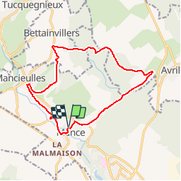
11.1 km | 13.8 km-effort
3h 8min
![](https://static1.geolcdn.com/siteimages/upload/files/16400158638029165_repeat_loop_refresh_sync_direction_icon.png)
Yes
![Trail Walking Val de Briey - Briey en famille - Photo](https://media.geolcdn.com/t/375/260/7a2bae71-a77e-4de9-b61c-c53dacb17e80.jpg&format=jpg&maxdim=2)
![Walking Walking](https://static1.geolcdn.com/sitytour/trail-icons/101.png)
Briey en famille
Walking
Easy
Val de Briey,
Grand Est,
Meurthe-et-Moselle,
France
![](/images/other/stat-length.png)
8.1 km | 10.3 km-effort
2h 21min
![](https://static1.geolcdn.com/siteimages/upload/files/16400158638029165_repeat_loop_refresh_sync_direction_icon.png)
Yes
![Trail Horseback riding Val de Briey - Briey 1 - Photo](https://media.geolcdn.com/t/375/260/ext.jpg?maxdim=2&url=https%3A%2F%2Fstatic1.geolcdn.com%2Fsiteimages%2Fupload%2Ffiles%2F1524743154cheval.jpg)
![Horseback riding Horseback riding](https://static1.geolcdn.com/sitytour/trail-icons/301.png)
Briey 1
Horseback riding
Easy
Val de Briey,
Grand Est,
Meurthe-et-Moselle,
France
![](/images/other/stat-length.png)
9.2 km | 10.5 km-effort
1h 53min
![](https://static1.geolcdn.com/siteimages/upload/files/16400158638029165_repeat_loop_refresh_sync_direction_icon.png)
No
![Trail On foot Val de Briey - Boucle de Mance - Photo](https://media.geolcdn.com/t/375/260/ext.jpg?maxdim=2&url=https%3A%2F%2Fstatic1.geolcdn.com%2Fsiteimages%2Fupload%2Ffiles%2F1545311037marcheuse_200dpi.jpg)
![On foot On foot](https://static1.geolcdn.com/sitytour/trail-icons/100.png)
Boucle de Mance
On foot
Easy
Val de Briey,
Grand Est,
Meurthe-et-Moselle,
France
![](/images/other/stat-length.png)
10 km | 12.2 km-effort
2h 46min
![](https://static1.geolcdn.com/siteimages/upload/files/16400158638029165_repeat_loop_refresh_sync_direction_icon.png)
Yes
![Trail Mountain bike Les Baroches - VTT Baroche hatrize homecourt briey - Photo](https://media.geolcdn.com/t/375/260/ext.jpg?maxdim=2&url=https%3A%2F%2Fstatic1.geolcdn.com%2Fsiteimages%2Fupload%2Ffiles%2F1524743154velo.jpg)
![Mountain bike Mountain bike](https://static1.geolcdn.com/sitytour/trail-icons/202.png)
VTT Baroche hatrize homecourt briey
Mountain bike
Difficult
Les Baroches,
Grand Est,
Meurthe-et-Moselle,
France
![](/images/other/stat-length.png)
44 km | 50 km-effort
3h 18min
![](https://static1.geolcdn.com/siteimages/upload/files/16400158638029165_repeat_loop_refresh_sync_direction_icon.png)
Yes
![Trail Running Val de Briey - run matinal - Photo](https://media.geolcdn.com/t/375/260/ext.jpg?maxdim=2&url=https%3A%2F%2Fstatic1.geolcdn.com%2Fsiteimages%2Fupload%2Ffiles%2F1524743154running.jpg)
![Running Running](https://static1.geolcdn.com/sitytour/trail-icons/103.png)
run matinal
Running
Easy
Val de Briey,
Grand Est,
Meurthe-et-Moselle,
France
![](/images/other/stat-length.png)
10.1 km | 13.6 km-effort
55min
![](https://static1.geolcdn.com/siteimages/upload/files/16400158638029165_repeat_loop_refresh_sync_direction_icon.png)
Yes
![Trail Trail Les Baroches - footing boiser - Photo](https://media.geolcdn.com/t/375/260/ext.jpg?maxdim=2&url=https%3A%2F%2Fstatic1.geolcdn.com%2Fsiteimages%2Fupload%2Ffiles%2F1524743154running.jpg)
![Trail Trail](https://static1.geolcdn.com/sitytour/trail-icons/104.png)
footing boiser
Trail
Medium
Les Baroches,
Grand Est,
Meurthe-et-Moselle,
France
![](/images/other/stat-length.png)
11.2 km | 12.9 km-effort
1h 14min
![](https://static1.geolcdn.com/siteimages/upload/files/16400158638029165_repeat_loop_refresh_sync_direction_icon.png)
Yes
![Trail Walking Les Baroches - rando baroches - Photo](https://media.geolcdn.com/t/375/260/ext.jpg?maxdim=2&url=https%3A%2F%2Fstatic1.geolcdn.com%2Fsiteimages%2Fupload%2Ffiles%2F1553511878bg_sport_marche.png)
![Walking Walking](https://static1.geolcdn.com/sitytour/trail-icons/101.png)
rando baroches
Walking
Easy
Les Baroches,
Grand Est,
Meurthe-et-Moselle,
France
![](/images/other/stat-length.png)
11.2 km | 13.1 km-effort
1h 38min
![](https://static1.geolcdn.com/siteimages/upload/files/16400158638029165_repeat_loop_refresh_sync_direction_icon.png)
Yes
![Trail Running Les Baroches - running matinal - Photo](https://media.geolcdn.com/t/375/260/ext.jpg?maxdim=2&url=https%3A%2F%2Fstatic1.geolcdn.com%2Fsiteimages%2Fupload%2Ffiles%2F1524743154running.jpg)
![Running Running](https://static1.geolcdn.com/sitytour/trail-icons/103.png)
running matinal
Running
Medium
Les Baroches,
Grand Est,
Meurthe-et-Moselle,
France
![](/images/other/stat-length.png)
9.2 km | 10.2 km-effort
1h 0min
![](https://static1.geolcdn.com/siteimages/upload/files/16400158638029165_repeat_loop_refresh_sync_direction_icon.png)
Yes